The final day of the weekend of desert peak-bagging was to be an epic attempt at 5 summits along the San Ysidro mountains; Goat Benchmark, San Ysidro East Peak, The Sirens, Kay Benchmark and Ode Benchmark. With the unfortunate blisters on my foot, I was uncertain as to what I might be able to do. A bit before 6 am, I picked Susie Kara up and headed over to the dirt lot next to Jilbertos in Borrego Springs. There we synced up with Matt Bennett, who got in Bonny and White Benchmarks after we did Stage Benchmark yesterday, and with Greg Gerlach, who summited The Thimble the day before. The plan was to drive Matt’s car to the Anza-Borrego Springs Visitor Center parking lot and leave it there (paying the $10 parking fee), then transfer to my Outback and drive up to Ranchita to start hiking.
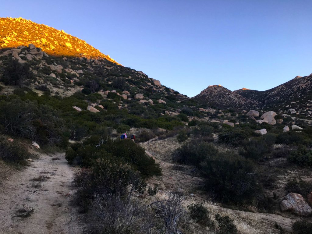
We parked just a bit further down the road from the BLM sign and began gearing up. Following the all too familiar route toward The Thimble along the road through Cherry Canyon. I could feel some slight discomfort from my foot, but I was confident that I could make our first peak, Goat Benchmark. After about a mile, Matt headed off to summit both The Thimble and San Ysidro. From there he would attempt to rejoin us before we ascended San Ysidro East Peak. With his fast pace and strong route finding, none of us doubted this would not be the case. I gave him some guidance on the route I took up The Thimble, and he was off. Greg, Susie and I then continued on to the east. Rather than stay on the road and cause any private property issues, we kept traveling cross-country.


Once we crested the ridge to the south of The Thimble, the chimney route was clearly visible from our vantage point. Susie recounted her ascent that way and the challenge it posed her. As we began our descent, we heard a voice call out, and there on the summit of The Thimble stood Matt! We stared in disbelief and in awe. We waved, knowing we would be seeing him probably even earlier than planned.

The three of us stuck to a gully which gave us fairly easy passage as we made our gentle descent. We kept scanning to the southeast, wondering if we could actually spot Goat Benchmark amongst the rocky bumps. It has a history of being hard to locate. However, with Greg’s track loaded on our devices, plus having him along, this became almost trivial.

We sat at the summit and took a nice break. The register was located atop the same boulder as the benchmark. Thankfully nature had provided a nice rock step, so climbing it was a simple task. After signing the register and taking some photos, it was time to head out. From here we would continue descending down into Hellhole Flats, before making the ascent up to San Ysidro East Peak.


Just as we crossed into Hellhole Flats, Matt gave out a shout to let us know he was rejoining us. We passed by Lookout Knob, just to the south of our route. Greg had summited it in the past and offered a few suggestions as to the route to the top. We all declined this time and continued on.

Once we reached the eastern edge of Hellhole Flats, we took another break before the ascent. I re-evaluated my foot’s condition. I added some additional padding, hoping it might reduce some of the pressure, and thus the discomfort. After some discussion, I felt I should not attempt San Ysidro East Peak. Instead, I would leave the group and head toward The Sirens. Once there, I would leave my arrival and departure time in the register, so the rest would have a sense of my location. Also, we knew once we reached that point, we would have cell coverage if needed.
I had always wondered how The Sirens got their name. Recently Larry Edmonds filled me in on its origin
A good friend who lives in Ranchita would look out at that short series of high points at the east end of Hell Hole Flat and call it “The Sirens” because they called to him. When the San Diego Peaks Club created there peak list they called the high point Sirens Peak because Paul Freiman, the creator of the peak list, and Ted, my friend, were also friends.
Larry Edmonds

So, I set off up a gully toward the saddle before turning southward. The Sirens were about a mile or so south at this point. I would follow the contours of the ridge as I drew closer to the summit. While I had Greg’s track loaded, I knew as I reached its base that it was now really my own navigation skills that I would take to the top. I plotted a route and began working my way up. As I drew closer and closer, I hoped that I had picked a route that would work. At one point, I was uncertain as to the path forward, however, there was a small cave that seemed to provide an option to explore. I worked my way through it and found myself much closer to Greg’s track. This gave me hope that I would find my way. After carefully traversing up a rocky slab, I found myself atop the summit. While I was not with the rest of the group working their way up to San Ysidro East Peak, I was feeling proud of making this one solo.


After signing the register and taking in the views. I turned my phone’s cell service back on and sent a text to the group (and my wife) of my current status. I was now going to continue on down toward Kay Benchmark. I took a more direct line with my descent from The Sirens. Now for probably the hardest part of the entire hike—the descent from The Sirens to Kay Benchmark. Every trip report I had read about this section spoke not only of the steepness but of the large boulders that also needed to be overcome. I tried to follow the track that Greg had done during his last trip, but at times I would drift off the track and would have to correct.

After almost 2 hours of careful route work, I found myself standing atop Kay Benchmark! I slid off my pack and leaned against a rock. As I sat there, I looked back to the west at what I had just navigated down solo. The plan was to wait here for Greg, Susie, and Matt to rejoin me. I checked back in with my wife, as the wind was starting to pick up some. Way off in the distance, I would hear the faint sounds of Matt and Susie, but even though Susie was wearing a bright pink top, I could not locate them. Finally, I spotted them! Turns out, they opted to follow the route Matt used on his previous trip. According to Greg, this was far superior to his previous route. He thought it only took them just over an hour to descend.


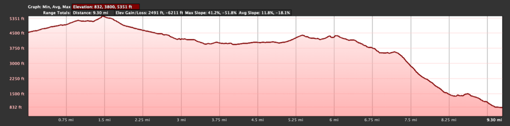
The winds continued to gust, even blowing my hat off at one point. Thankfully, a cholla caught it for me. We still had several more miles to go until we reached the visitors center, and about 2,500 feet of elevation to still lose, so we headed off. The terrain continued to be steep and rocky, but we were able to generally follow the ridgeline the entire way.


Off in the distance, we could see Ode Benchmark, our final peak of the day, poking up from the spine of the ridge, way below us. We continued working our way down. The terrain thankfully finally eased up some, as all the miles and climbing were taking their toll. With one final bit of climbing, we reached Ode Benchmark! Since I had previously summited this peak about a year ago, I snapped a quick photo of the benchmark and kept on trucking.

My foot was starting to hurt a bit more and I was looking forward to a nice cool drink of water at the Visitor Center. There was finally a decent use trail to follow, so my pace quickened slightly. The sun was setting, and the Santa Rosa mountains were beautifully lit. Soon, we reached the desert floor and I motored across it, to the promise of that cool water. We had done it! Our 10:35-hour day was done.


We headed back into town for some well-earned Mexican food, then Greg drove me back up to Ranchita to retrieve my car. While I had to skip the ascent of San Ysidro East Peak, I was still happy with my trek. I now have just 17 more peaks to climb to complete the Sierra Club-San Diego 100.
Final Stats
Start: 6:45 am
Reached Goat: 8:55 am
Reached The Sirens: 11:40 am
Reached Kay: 1:50 pm
Reached Ode: 4:50 pm
Visitor Center: 5:20 pm


I am an avid peak bagger, sometimes backpacker, and former sea kayaker living in San Diego. I am the co-author of Urban Trails: San Diego, available now!
In 2019, I became the third person to complete the San Diego 100 Peak Challenge. Not stopping with that accomplishment, I set my sights on the harder San Diego Sierra Club 100 Peak list, which I completed in 2021. In addition, I have conquered several Six-Pack of Peaks challenges (SoCal, San Diego, Central Coast, and both the Arizona-Winter and Arizona-Summer).
I am looking forward to exploring new summits and new adventures across the southwest.
One thought on “The Sirens and Goat, Kay, and Ode Benchmarks”