Trip Reports

Hiking the Duck Pond Loop

With the predicted rain coming (yay!), I decided to get in a quick mid-day hike. I drove over to Elizabeth Rabbitt Park and set off down toward the Duck Pond. This is a popular route for mountain bikers, but on a Wednesday afternoon, I doubted I would see but one or two. Quickly, I found myself at the pond, and after a brief survey of it, I continued on down to Peñasquitos Canyon.

This route drops you almost directly at the waterfall. I circled around to the south side and took a few photos in the afternoon sun. 

I continued westward through the canyon, passing several large pools that lined the trail. At times, the trail would split, with one path for horses and another for other users. I passed the Sycamore Crossing and continued until I reached the Side Hill Trail that I would use to climb out of the canyon and back onto the mesa. It did afford a nice view of the canyon from near the top of the trail.

Once back at the mesa, I followed the wide and well-groomed trail that follows the road. From time to time, dry vernal pools would line either side of the trail. If we get enough rain, this might be worth revisiting. Soon, I was back at my starting point, having logged 4.3 miles in just over 1:20.


Buy Me a Coffee at ko-fi.com

I am an avid peak bagger, sometimes backpacker, and former sea kayaker living in San Diego. I am the co-author of Urban Trails:San Diego, coming in Spring 2026!

In 2019, I became the third person to complete the San Diego 100 Peak Challenge. Not stopping with that accomplishment, I set my sights on the harder San Diego Sierra Club 100 Peak list, which I completed in 2021. In addition, I have conquered several Six-Pack of Peaks challenges (SoCal, San Diego, Central Coast, and both the Arizona-Winter and Arizona-Summer). I am looking forward to exploring new summits and new adventures across the southwest. 

A visit to Ted Benchmark

As we cruised out toward Anza-Borrego, the eastern sky was glowing a fiery red as the sun began to rise above the mountains. The plan for today was to hike up the ridgeline to Webo Benchmark which sits atop its end. Along the way, we would pass over Ted Benchmark. Rick and Andrea needed both toward their quest to complete the San Diego Sierra Club 100 peak list. I had done this hike several times before, but I was happy to make the climb again, as who doesn’t love a good desert hike? The parking area had one other car there when we pulled in just after 7:30. Rick went to pay the $10 day-use fee, while I liberally applied some Voltaren on my achy left knee. Once we were geared up, we set off down the trail that most visitors take to view Maidenhair Falls (which given the lack of rain probably are not even flowing). The weather was pleasant, even a touch warm. After about a mile, we headed cross-country for a short distance before ascending onto the ridgeline that we now followed toward our destination.

We weaved our way upward, avoiding the various cacti along our journey. Rick and I cruised along carrying a good pace, but Andrea just wasn’t feeling it. Something I can relate to. She felt that she could make it Ted Benchmark, but would probably turn back at that point. Once Rick and I reached Ted Benchmark, we signed the register and snapped a few photos. We then began discussing options: do we continue on up to Webo and give the car keys to Andrea and let her return solo, or do we all just turn back and get Webo another time (either repeating this hike or tacking it on when we try for San Ysidro East)? In the end, we opted to return together and drive over to scout Sunset Mountain for them. Once off the ridge, we encountered a few folks headed to the falls and the nearly empty parking lot now had quite a few more cars parked.

It was still too early for lunch as we drove through Borrego Springs on our way over to Pinyon Canyon. Turning off the 78 onto the dirt road, we cruised along the fairly well-groomed route. We parked near the starting point I used the last two times when I climbed Sunset Mountain and gave them a brief rundown of the route. Once that was completed, we continued driving down the road, wondering what it might lead to. Finally, the road came to an end, and we then retraced our route back into Borrego Springs and grabbed lunch at Los Jilbertos. With our stomachs now full, we drove home. While we didn’t get both benchmarks, we did have a nice 4.2-mile hike and were able to explore a little bit more of Anza-Borrego.


Buy Me a Coffee at ko-fi.com

I am an avid peak bagger, sometimes backpacker, and former sea kayaker living in San Diego. I am the co-author of Urban Trails:San Diego, coming in Spring 2026!

In 2019, I became the third person to complete the San Diego 100 Peak Challenge. Not stopping with that accomplishment, I set my sights on the harder San Diego Sierra Club 100 Peak list, which I completed in 2021. In addition, I have conquered several Six-Pack of Peaks challenges (SoCal, San Diego, Central Coast, and both the Arizona-Winter and Arizona-Summer). I am looking forward to exploring new summits and new adventures across the southwest. 

Strolling along the Tidal Trail

With the trails dry enough to hike on, I made the short drive toward Del Mar to explore the new Tidal Trail. This trail was recently opened as part of the Coast to Crest system and it shares the trailhead with the Dust Devil Nature Trail. I brought our dog along to enjoy some trail time. We began along the North Loop of the Dust Devil Trail for about 0.2 miles to the junction with the Tidal Trail. The well-groomed and wide dirt trail went northward for a short bit before turning eastward, following the edge of the estuary. Birds could be seen probing the mud and the shallow water in search of a tasty morsel. The route is basically flat, so we cruised along. While the sounds of the cars whizzing along El Camino Real could be heard, they were mostly out of sight. The trail made another turn northward before coming to an end.

We turned back and continued to enjoy the views. Since I had an injection the day before in my knee, I opted not to continue hiking on the Dust Devil Nature Trail and called it a day. Plus, I would not have to edit the GPS track to only show the Tidal Trail. The hike was just about 2.3 miles and with a few dog-related breaks we did it in 45 minutes.


Buy Me a Coffee at ko-fi.com

I am an avid peak bagger, sometimes backpacker, and former sea kayaker living in San Diego. I am the co-author of Urban Trails:San Diego, coming in Spring 2026!

In 2019, I became the third person to complete the San Diego 100 Peak Challenge. Not stopping with that accomplishment, I set my sights on the harder San Diego Sierra Club 100 Peak list, which I completed in 2021. In addition, I have conquered several Six-Pack of Peaks challenges (SoCal, San Diego, Central Coast, and both the Arizona-Winter and Arizona-Summer). I am looking forward to exploring new summits and new adventures across the southwest. 

Hiking Big Rock to Cowles Mountain

I decided to hike up Cowles Mountain via the Big Rock Trail. Believe it or not, I have actually never taken this route up Cowles as I generally take the Baker Way route when I care to climb this peak. I pulled into street parking and gathered my gear. It was still a bit chilly and the first part of the ascent would be on the northern slopes of the mountain. The trail passed by the dog park and the empty paddleball courts. Then the trail split, and the left fork climbed a short hill, while the right path skirted it. Off in the distance stood the communication towers next to the summit of Cowles Mountain.

The trail crossed a dry creek before beginning its real climb and I cruised along the fairly well maintained path. As the trail worked its way upward, I was afforded some nice views to the north – Woodson, Iron mountain and El Cajon Mountain were all standing tall.

I soon came to the junction with the Mesa Trail but stayed on the Big Rock Trail. Once it reached the service road, the warmth of the sun was enough to have me shed the light fleece I had been wearing. I had a short flat stretch before the road began its fairly steep climb to the summit, as it is designed for trucks and not hikers. As I reached the summit I took a moment to soak in the views. It was a very clear day, and standing atop the highest point in the City of San Diego offered up some nice vistas. After snapping a few photos, I extended the length of my trekking poles to assist with the steep descent and headed back down.

The return went quickly, and I gave friendly nods to others as they made their way up. As I neared the paddleball courts, they were now filled with players. I collapsed my poles and turned off my tracker. It recorded the trip as 4.8 miles in 1:56 (including the time at the summit).


Buy Me a Coffee at ko-fi.com

I am an avid peak bagger, sometimes backpacker, and former sea kayaker living in San Diego. I am the co-author of Urban Trails:San Diego, coming in Spring 2026!

In 2019, I became the third person to complete the San Diego 100 Peak Challenge. Not stopping with that accomplishment, I set my sights on the harder San Diego Sierra Club 100 Peak list, which I completed in 2021. In addition, I have conquered several Six-Pack of Peaks challenges (SoCal, San Diego, Central Coast, and both the Arizona-Winter and Arizona-Summer). I am looking forward to exploring new summits and new adventures across the southwest. 

A windy hike to Cuyamaca Peak

Having knocked out two peaks on the San Diego Six Pack of Peaks challenge on New Year’s Day, I decided to cross another off the list — Cuyamaca Peak. While the forecast did call for some windy conditions, that did not deter me. I arrived at the trailhead just before 8. Unlike last time when I was racing against the heat of the day, this time I wanted some of the sun’s warmth to offset the winter chill. I cruised along Milk Ranch Road, falling into a nice groove. I wondered if I might see any wild turkeys, and a few minutes later, almost 20 stood in a field next to the road.

The day felt more like a fall day rather than a day in January. I turned on to the Conejos Trail and began the climb in earnest. The legs still felt good, even after the adventure in the desert the day before. I passed two hikers making their way back from the summit. They said it was quite breezy up there. I thanked for the information and continued on. Once at the service road I slipped rubber tips onto my trekking poles as there was no need to wear down the metal tips on the asphalt. As I approached the summit, I could hear the wind at times whistling through the communications tower. The summit itself was actually fairly well sheltered, so I snapped my photos and enjoyed my PB&J. I didn’t linger past that, set off back down the road, and passed a few other hikers making their way to the summit.

The legs continued to feel good as I turned on to the Azalea Glen Fire Road. Just after the spring, I saw the SD Sloth group. Some of them had been on yesterday’s hike, so I knew they had this on their calendar. I said a quick hello before continuing on. Before too long the end of the trail came into view. I had resisted really looking at my time/pace, but was very curious what my final time would be. I did the 8.6 miles in 3:17! That was a great pace for me on this climb. Since I was solo, I decided to grab some tri-tip from Grand Ole BBQ in Flinn Springs, which hit the spot.


Buy Me a Coffee at ko-fi.com

I am an avid peak bagger, sometimes backpacker, and former sea kayaker living in San Diego. I am the co-author of Urban Trails:San Diego, coming in Spring 2026!

In 2019, I became the third person to complete the San Diego 100 Peak Challenge. Not stopping with that accomplishment, I set my sights on the harder San Diego Sierra Club 100 Peak list, which I completed in 2021. In addition, I have conquered several Six-Pack of Peaks challenges (SoCal, San Diego, Central Coast, and both the Arizona-Winter and Arizona-Summer). I am looking forward to exploring new summits and new adventures across the southwest. 

Finding the Solstice Cave

When I saw the hike announcement from the Jacumba Hikers that they were leading a hike in Indian Gorge to a “hidden” cave, I knew that they were headed to the Solstice Cave near Sombrero Peak! I had known of this cave for some time, and had always wanted to see it in person. I drove out to the Imperial Valley Desert Museum to rally with our trip leaders. Since my Outback was still out of commision, I would need to carpool out to the actual trailhead. Several of the San Diego Sloth Hiking Group also arrived for the trek, and after signing our waivers, we piled into two capable vehicles and set off. The road to the trailhead took some care — not as bad as Carrizo Gorge, but certainly one that requires some off-road driving skills.

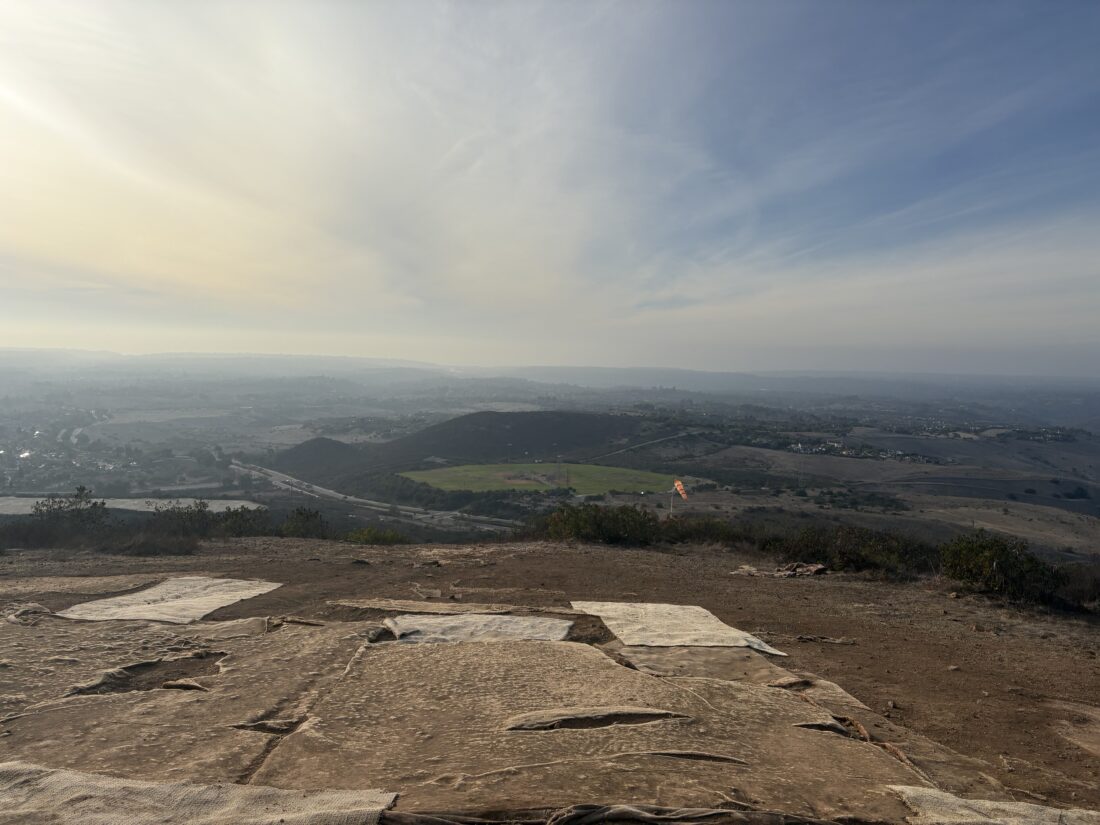
The familiar trailhead for the east approach of Sombrero Peak came into view. A small palm grove stood just to the west. We gathered our gear and set off. Mike took the lead, following the use trail that faded in and out as we made our way up the drainage. Instead of turning left to follow the route that I took on two of my summits of Sombrero Peak, we continued westward. We climbed up over the boulders and through the cat’s claw and cacti. From time to time we would stop and regroup, as the terrain would cause us to spread out a bit. While some were very comfortable hiking in this terrain, others were less so. 

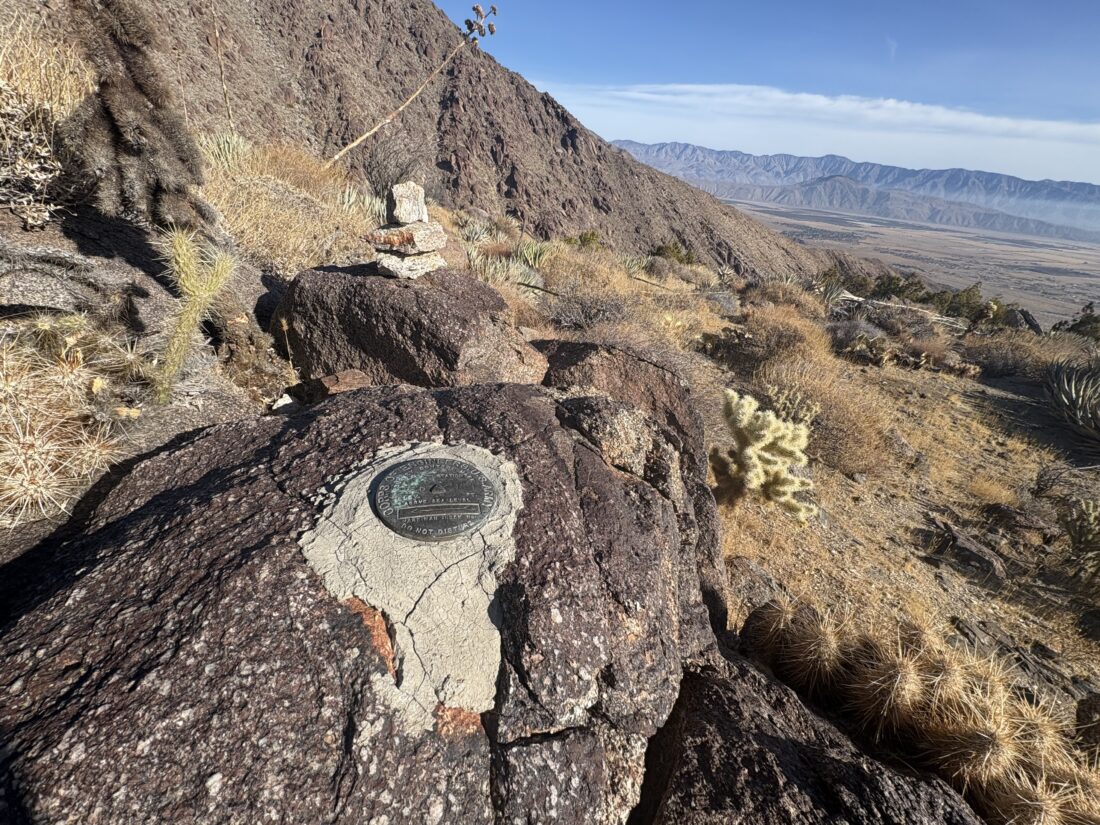
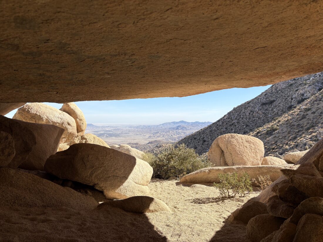
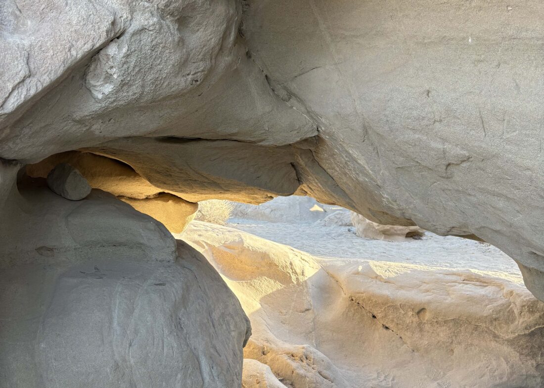
I soon found myself with Mike at the head of the group, and as we neared our destination, it became a game of double checking which rock cluster in which the cave was actually located. When we reached the first set of boulders where Mike thought it was, I offered to scramble around to see if the cave was there. After turning up empty, we set off higher on the slopes to another grouping of large boulders. I again scouted ahead and soon found the rear entrance to the cave! While I had it to myself, I took in the significance of this place for a moment, before stepping out to the front of the cave and signaling to the group its location. They soon filed in and began to marvel at the pictographs along the ceiling. We also had a stunning view back down the drainage. Sombrero Peak stood to our south. 

Orange and red-hued suns are placed throughout the ceiling with other forms, some seemingly human, found in the back of the cave. A pointed rock also stands to the south of the cave entrance. Some think this might act as a sundial, giving this cave its name. After a snack and retrieving one of my water bottles that had fallen down some rocks, we bid the cave goodbye. Our trip leaders decided to try following a route more on the southside of the drainage, rather than fully retracing our route. I worked with Mike to pick our route across the hillside. After some “fun” side-hilling, we decided to drop down toward the base of the drainage. I took the lead, and soon found myself back along the route we used during our ascent. I continued on down the drainage, feeling right at home hiking solo through the desert. Soon I spied the palm grove at the trailhead, and then our cars. I sat in the shade from one of the cars as I waited for the rest of them to make their way down. Once we were all together, cold drinks and snacks were kindly provided. Then we loaded back up and began the drive out. Along the way, we passed two brothers who were out hiking the road. We certainly did not expect that. Once back at the museum’s parking lot, I thanked our trip leaders and set off home. 

Due to the historic and sacred nature of this cave, I am not posting my actual GPS track for this hike.


Buy Me a Coffee at ko-fi.com

I am an avid peak bagger, sometimes backpacker, and former sea kayaker living in San Diego. I am the co-author of Urban Trails:San Diego, coming in Spring 2026!

In 2019, I became the third person to complete the San Diego 100 Peak Challenge. Not stopping with that accomplishment, I set my sights on the harder San Diego Sierra Club 100 Peak list, which I completed in 2021. In addition, I have conquered several Six-Pack of Peaks challenges (SoCal, San Diego, Central Coast, and both the Arizona-Winter and Arizona-Summer). I am looking forward to exploring new summits and new adventures across the southwest. 

Hiking Volcan Mountain

After hiking up Woodson Mountain earlier in the day, I drove out to Volcan Mountain to cross my second peak off the 2025 Six Pack of Peaks Challenge. As I turned on the Farmers Road, I could see this trail was going to be busy. However, just as I neared the actual trailhead, a car left, and I was able to grab a parking spot right at the start. The day had warmed some, but there was a slight breeze. I decided to leave the fleece behind, as I wasn’t planning on hanging out at the summit for any real length of time. 

The legs still felt good after my 5 miles up Woodson, and I motored along the trail. I decided to skip taking the 5 Oaks Trail, just save a little distance this time. New Year’s greetings were exchanged as returning hikers passed me. Soon, the summit and its navigation tower came into view. Some hikers were enjoying their well-earned snack at the picnic bench, while I snapped another summit badge photo. I stopped by the benchmark and chatted with two other hikers before heading back down from the summit. 

More and more folks, many with their dogs (did I miss the “bring your dog to Volcan Mountain” memo?) were working their way toward the top. I kept cruising down the trail, and as Farmers Road came back into view, there were a lot more cars parked along it. Back at the car, I changed into a dry shirt and headed home. I made a quick stop at Don’s Market for a cold soda before making the rest of the drive. As I passed the trailhead for Woodson Mountain, the side of the highway was now completely jam packed with cars. I could only imagine the line to climb onto the ‘Chip’. It was a great way to kick off 2025, with hopefully a lot more adventures to come.


Buy Me a Coffee at ko-fi.com

I am an avid peak bagger, sometimes backpacker, and former sea kayaker living in San Diego. I am the co-author of Urban Trails:San Diego, coming in Spring 2026!

In 2019, I became the third person to complete the San Diego 100 Peak Challenge. Not stopping with that accomplishment, I set my sights on the harder San Diego Sierra Club 100 Peak list, which I completed in 2021. In addition, I have conquered several Six-Pack of Peaks challenges (SoCal, San Diego, Central Coast, and both the Arizona-Winter and Arizona-Summer). I am looking forward to exploring new summits and new adventures across the southwest. 

New Year’s Day on Woodson Mountain

I decided to kick off 2025 by tackling Woodson Mountain. Driving to the Fry-Koegel trailhead, I was surprised at the lack of cars parked along Hwy. 67, especially as the Iron Mountain parking lot was packed when I drove past. It was a bit chilly, and much of the hike is on the northern side of the mountain (aka in the shade), so I slipped on a light fleece. I knew I would warm up as I began my climb, but I thought it was still just a tad too cold to not have on an extra layer. This route is now my preferred route to ascend Woodson Mountain. As I passed the houses at the beginning, the smell of a fire in a fireplace filled the air, along with the scent of bacon….

I did start to heat up, so I shed that fleece, and motored on up the trail. After joining the Poway Trail, I drew closer to the summit. I could see a modest crowd milling around the Potato Chip, snapping their photos. I stopped for a short break, snapped a photo with this year’s Six Pack of Peaks badge in front of the iconic landmark, then left the crowd behind. I made a quick stop at the true summit (I did not scale the boulder) before beginning the steep descent on the paved service road. I remembered to bring the rubber tips for my trekking poles, in order to protect their metal tips.

As I cruised down, scores of folks were huffing and puffing their way up. Several had the look of “how did I get talked into this?” on their faces. Once at the bottom, I returned to the car, tossed in my gear and headed off to Volcan Mountain for my second summit of the day!


Buy Me a Coffee at ko-fi.com

I am an avid peak bagger, sometimes backpacker, and former sea kayaker living in San Diego. I am the co-author of Urban Trails:San Diego, coming in Spring 2026!

In 2019, I became the third person to complete the San Diego 100 Peak Challenge. Not stopping with that accomplishment, I set my sights on the harder San Diego Sierra Club 100 Peak list, which I completed in 2021. In addition, I have conquered several Six-Pack of Peaks challenges (SoCal, San Diego, Central Coast, and both the Arizona-Winter and Arizona-Summer). I am looking forward to exploring new summits and new adventures across the southwest. 

Hiking the Glider Port Loop

I decided to wrap up 2024 with another hike around Black Mountain. There were a few cars in the parking lot for Miner’s Ridge when I pulled in. My general plan was to take the Miner’s Ridge trail, then connect over to the Glider Port Trail and loop back to the start. As I cruised along the trail, I spent some time reflecting on the year, but those are my thoughts… When I reached the junction with the trail that would take me to the summit, I decided to go ahead and take it. The legs still felt good as I climbed the rocky path upward. Once at the summit, I snapped a couple of photos and headed back down.

I made the quick side trip to summit Peak 1376, because why not? I then continued hiking down toward the Glider Port itself. Living nearby, we see parasailers soar around the skies. Leaving the launching area behind, I headed to the Lilac Canyon Trail and followed it back to the Miner’s Ridge Trailhead. A nice loop to cap off 2024! To kick off 2025, I am thinking of a two-fer; Woodson Mountain, followed by Volcan Mountain if my legs feel good.


Buy Me a Coffee at ko-fi.com

I am an avid peak bagger, sometimes backpacker, and former sea kayaker living in San Diego. I am the co-author of Urban Trails:San Diego, coming in Spring 2026!

In 2019, I became the third person to complete the San Diego 100 Peak Challenge. Not stopping with that accomplishment, I set my sights on the harder San Diego Sierra Club 100 Peak list, which I completed in 2021. In addition, I have conquered several Six-Pack of Peaks challenges (SoCal, San Diego, Central Coast, and both the Arizona-Winter and Arizona-Summer). I am looking forward to exploring new summits and new adventures across the southwest. 

Exploring the Wind Caves

After camping somewhere along Fish Creek Wash, we stopped at the Wind Caves on our way out. We followed the trail up out of the wash and worked our way 0.5 miles to them. I have been here twice before, but previously just made a quick stop before heading on toward the summit of Split Mountain East, so I never really explored them. This time we took our time to explore the area. There are some pretty big caves off to the south of the main trail.

Since we opted not to have a real breakfast at camp, we both were starting to get hungry, so we wrapped up our exploration of the caves and headed back to the car. We had an uneventful drive back out, and before too long a nice hot breakfast at the Red Ocotillo in Borrego Springs sat before us. A nice way to cap off three days and two nights of desert adventures with my son.


Buy Me a Coffee at ko-fi.com

I am an avid peak bagger, sometimes backpacker, and former sea kayaker living in San Diego. I am the co-author of Urban Trails:San Diego, coming in Spring 2026!

In 2019, I became the third person to complete the San Diego 100 Peak Challenge. Not stopping with that accomplishment, I set my sights on the harder San Diego Sierra Club 100 Peak list, which I completed in 2021. In addition, I have conquered several Six-Pack of Peaks challenges (SoCal, San Diego, Central Coast, and both the Arizona-Winter and Arizona-Summer). I am looking forward to exploring new summits and new adventures across the southwest.