Returning to Oriflamme

We opted to try to work on knocking out one of Ted’s remaining peaks. There was just one problem – it was going to be a bit windy for all of them. In the end, we settled on Oriflamme Mountain. As we drove out and passed Santa Ysabel, the various flags flying around were straight out. We pulled into the parking area and gathered our gear. I slipped on a fleece and made sure to put a wind shell in my pack. We crossed Sunrise Highway and headed down the old Jeep road.

We cruised along, passing the rusted wreck of a truck. Maybe “Matt’s Off-Road Recovery” could remove it! I spotted the point where we would leave the road and begin the short climb to the summit. There isn’t a trail, but rather the need to use a best-guess method through the brush. For the most part, I got us to the top without any issues. It was quite breezy there, so we snapped a few photos, double checked for a register, and headed back down. We again weaved through the brush and actually exited at exactly the same point, back onto the road! We climbed back up to the car, (got to love those inverted hikes) and along the way, I outlined all my 2026 hiking goals. No surprise, I’ve got a ton!


Buy Me a Coffee at ko-fi.com

I am an avid peak bagger, sometimes backpacker, and former sea kayaker living in San Diego. I am the co-author of Urban Trails: San Diego, available now!

In 2019, I became the third person to complete the San Diego 100 Peak Challenge. Not stopping with that accomplishment, I set my sights on the harder San Diego Sierra Club 100 Peak list, which I completed in 2021. In addition, I have conquered several Six-Pack of Peaks challenges (SoCal, San Diego, Central Coast, and both the Arizona-Winter and Arizona-Summer).

I am looking forward to exploring new summits and new adventures across the southwest. 

Chino Hills Loop

With my spring break plans in flux, and the desert still too warm for any significant peak bagging, I opted to knock out a couple of peaks on the Lower Peaks Committee list. I made the drive up to Chino Hills State Park to do a loop that would have me pass over Gilman Peak and San Juan Hill. Starting from the Rimcrest Trailhead, I began my clockwise trek heading down toward Telegraph Canyon. The morning was cool, and the plants that encroached onto the trail were still damp with the morning dew. Soon, the legs of my pants, and my shoes, were soaked.

Once I reached Telegraph Canyon, I hiked in solitude until I reached the Gilman Peak Trail. I then began the climb toward my first summit. Some wildflowers dotted the hillside, but it was mostly black mustard, which is actually an invasive plant. The summit of Gilman Peak soon came into view, and I found the California Highway Marker atop it. A snowcapped Mt. Baldy loomed to my north, making for a lovely sight. After a quick snack, I followed the North Ridge Trail for a bit before dropping back down. A shaded rest area could be seen, along with an informational kiosk. I mixed up my electrolytes before beginning the climb up out of the canyon and onto San Juan Hill.

Once on the South Ridge Trail, I made the short climb to the summit of San Juan Hill. Here I found the reference marker and the concrete summit marker from 1896. Again, I enjoyed the clear views from the summit before heading back to the car. I began passing others out enjoying the trail. Soon, I spotted the trailhead where I started, and my loop was done. This loop was 9.7 miles with a total gain of 1412 feet, and I covered it in 3:34.


Buy Me a Coffee at ko-fi.com

I am an avid peak bagger, sometimes backpacker, and former sea kayaker living in San Diego. I am the co-author of Urban Trails: San Diego, available now!

In 2019, I became the third person to complete the San Diego 100 Peak Challenge. Not stopping with that accomplishment, I set my sights on the harder San Diego Sierra Club 100 Peak list, which I completed in 2021. In addition, I have conquered several Six-Pack of Peaks challenges (SoCal, San Diego, Central Coast, and both the Arizona-Winter and Arizona-Summer).

I am looking forward to exploring new summits and new adventures across the southwest. 

Exploring Cody & Pike Benchmarks, again

Several months ago, I arranged with Gina to be able to hike down to Palm Mesa High Point from Los Coyotes, figuring the end of February would be perfect to attempt it. Rick and Andrea were also going to join me to climb Cody & Pike Benchmarks. Well, Mother Nature had other ideas with an unseasonably hot spell. We wisely decided to cancel my attempt to summit Palm Mesa High Point, as it is an inverted hike and fully exposed. Instead, I would join Rick and Andrea on their efforts to bag Cody & Pike. We met at Gina’s lovely home, and piled into her car to drive into the deeper parts of the reservation. Wild turkeys and deer were spotted as we passed through the locked gates. We parked past the San Ignacio Cemetery, where some of her husband’s family is buried. We gathered our gear and set off down the road before dropping into the wash that would take us up to the ridge. Gina had left cairns for herself, as she does come wandering out here from time to time, we redubbed the cairns as “Ginas”.

At the saddle, with Anza-Borrego spread out before us, Gina wasn’t feeling it. She sent us off, and she was going to chill and maybe stroll over to Dry Benchmark. The rest of us opted to skip climbing Phil and Norte Benchmarks and stay true to the primary benchmarks. I led the way through the brush, roughly following the track Gina and I took several years ago. Other than the brush being a bit thicker, it was a fairly straightforward ascent. Rick might disagree, as he did opt to wear shorts. At the summit, we took a break, signed the register, and took in the views before returning to the saddle and then onto Pike.

We followed the exit track that Gina and I used to avoid climbing up past Army Benchmark (which has been delisted in Peakbagger). I got a text from Gina that she was feeling better and had wandered over to Pike and would wait for us there. I found a deer trail and used that to cut across toward Pike. The day was warming, which reinforced my decision not to try for Palm Mesa High Point. We bypassed Pike Benchmark Summit and headed directly for Pike Benchmark. It is on the San Diego Sierra Club list, while the other is not. Gina was soaking in the views as we joined her.

We ate our lunches, again marvelling in the views, while a light breeze helped keep us cool. Rick and Andrea made the short climb over to Pike Benchmark Summit. I opted to skip it as I might be headed to Arizona for some hiking over the next four days. Gina and I side-hilled around it. When we reached a small saddle, Gina realized that she lost her phone. She had taken a call from her youngest, so we had an approximate area where it might be. She doubled back, and I waited a bit to begin calling it, so that it might be heard if it was not directly visible. Thankfully, she found it. When she went to return her phone to her shoulder case, she must have missed it. Crisis averted. We reached that initial saddle, and shortly thereafter, Rick and Andrea rejoined us. We took another short break and then headed back down to the car. While I did not get the peak I was after, it was still a great day out hiking with some great friends. The final stats were 5.7 miles in 6:00 with 1,130 feet of gain/


Buy Me a Coffee at ko-fi.com

I am an avid peak bagger, sometimes backpacker, and former sea kayaker living in San Diego. I am the co-author of Urban Trails: San Diego, available now!

In 2019, I became the third person to complete the San Diego 100 Peak Challenge. Not stopping with that accomplishment, I set my sights on the harder San Diego Sierra Club 100 Peak list, which I completed in 2021. In addition, I have conquered several Six-Pack of Peaks challenges (SoCal, San Diego, Central Coast, and both the Arizona-Winter and Arizona-Summer).

I am looking forward to exploring new summits and new adventures across the southwest. 

No Knob!

Originally, I had planned to hike up to Rosa Point and Mile High on Sunday, but one set of friends had to back out, and another let me know that his legs were a bit worn from climbing Sawtooth (the one on the SD Peak Club list). So I suggested that Robert and I explore and see if we might be able to climb Knob Benchmark from Sheep Canyon. At worst, it would be another great hike out to Sheep Canyon, and we’d probably have some wildflowers to enjoy as well. We met around 7 at the parking lot next to Jilbertos and transferred into the Outback. Robert and I drove out to the gate at the third crossing. We parked, gathered our gear, and set off. There were quite a few more flowers than last time as we hiked along the stream.

After the climb over Boulder Alley, we met a group of Boy Scouts returning from their overnight. Earlier, we had met a couple of bike-packers. As we got closer to Sheep Canyon, we could see where the recent rains had traveled across the desert sands. We walked over to the campground where another group of backpackers was milling around a picnic table. I assumed they might be WBC course participants, since a lecture was being held. Even with the closure, this is still a busy place. We found another table and had a quick snack break. Now onto the real adventure—could we find a route through Sheep Canyon, then onto Knob Benchmark? The route I had taken before is no longer available, so I was exploring alternatives.

As we headed into the canyon, the sounds of flowing water began to fill the air. A really good flow poured through the brush. That is a good sign for us if we can get in a backpacking trip to attempt SquareTop, as we will need to haul out very little with us. Maybe we could bring some firewood instead? We began slowly, picking our way through the brush and rocks, crossing the creek a few times. After almost an hour of pushing through the increasingly dense growth and only covering about 1/2 mile, we called it. We felt the canyon was going to get thicker and harder. Knob Benchmark is going to require a different route. We got back to the campground and had another snack before heading out. The day had warmed some, an indication of the warmer forecast for the coming week. We cruised back, stopping at the marker again. As we neared the gate, there were a lot more folks out enjoying the flowers. We drove back into town, grabbed a couple of sodas, and enjoyed our lunch at a picnic table under the shade of a cottonwood. While we never got close to the peak, it was still a fantastic day in the desert with some good company.


Buy Me a Coffee at ko-fi.com

I am an avid peak bagger, sometimes backpacker, and former sea kayaker living in San Diego. I am the co-author of Urban Trails: San Diego, available now!

In 2019, I became the third person to complete the San Diego 100 Peak Challenge. Not stopping with that accomplishment, I set my sights on the harder San Diego Sierra Club 100 Peak list, which I completed in 2021. In addition, I have conquered several Six-Pack of Peaks challenges (SoCal, San Diego, Central Coast, and both the Arizona-Winter and Arizona-Summer).

I am looking forward to exploring new summits and new adventures across the southwest. 

Urban Trails: San Diego Update!

The book’s formal release is fast approaching, and I wanted to let everyone know of some upcoming events.

Warwick’s La Jolla

4/19 1:00 – 3:00 PM

Come chat with Chris and Susie and get your copy of Urban Trails: San Diego signed!

Details

Helix Brewing Company

4/22 (Earth Day) 6:30 pm

Come grab a pint and hear Susie and Chris talk about Urban Trails, hike challenges, and more!

Details

The Book Catapult

The Book Catapult

5/3 11:00 AM

Join Susie and Chris for a short urban hike, then a short talk and book signing.

Details

Also, here is a sneak peek from inside the book:

Returning to Villager

The original plan was to summit Indianhead via Palm Canyon, but the forecast temperatures led us to postpone our attempt to a later date. Since we had planned for a pre-dawn start, I had booked a campsite at Borrego Palm Canyon Campground. I opted to keep the reservation, spend the night out there, and hike something else in the morning. After setting up my Luno mattress, I relaxed around the campsite a bit until the sun dipped below the mountains. I opted to bring a new backpacking meal, Chicken Tikka Masala from Bowl and Kettle, to try out. I also brought some naan from Trader Joe’s, which I warmed over the campfire. As the sunlight faded across the desert, I sat back and enjoyed my meal. My fire burned faster than expected, with a combination of dry wood and a slight breeze, so I turned in early and listened to some lectures.

The alarm went off just after 5 am, and I made some oatmeal and coffee as I quietly broke camp. I decided to climb Villager Peak as my replacement for Indianhead. For those who are familiar with Villager, it is still a hard hike. It’s just under 14 miles round trip, but for the most part, a straightforward ridgeline to the summit. There are trees at the summit, so if I cared to take a nap in the shade, I could. The trailhead was empty when I pulled in. Driving over from the campground, I saw the temperature dip into the high 40s. Here it read in the low 50s, so I left my fleece in the car. Between the coming dawn and the quarter moon hanging in the western sky, I had plenty of light to set off across the desert floor to the Villager Ridge. I found the use trail shortly after leaving the trailhead, and cruised along. I crossed over the Rattlesnake Wash and up the steep slope to begin climbing.

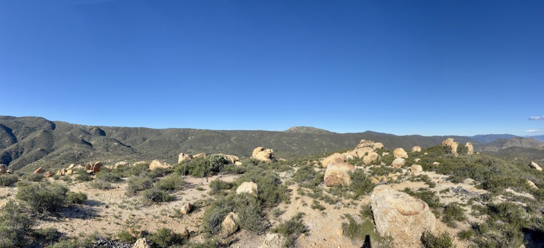
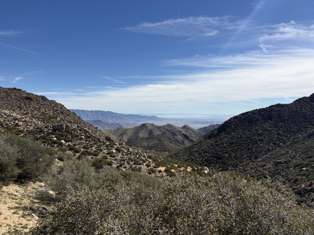
The sun finally rose above the mountains to the east, and a light breeze began to blow. Between the cairns and the use trail, there were no issues as I kept plodding along. From time to time, a steeper section would require some additional effort, but nothing too sustained, and a flatter section would follow to allow for some recovery. My left calf was feeling a bit off, and it gradually tightened as I hiked on, despite attempts to stretch it out. As I passed Mile High off to the east, the Salton Sea finally came into view. I looked across at that peak and gazed at what I had hiked down and up when I had summited it. While I still need to climb it again, I think I will take an alternate route down.

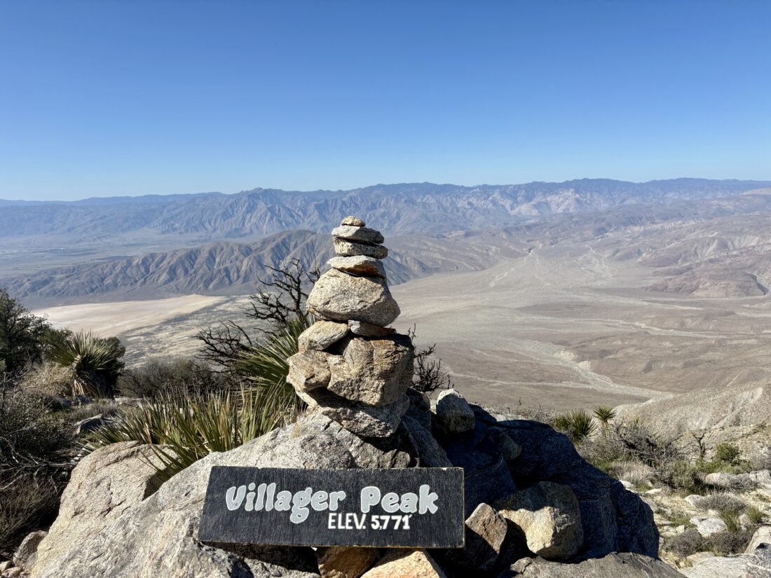
The Backpacker Radio Podcast kept me entertained as the summit drew near. I crested the small false summit and soon found myself staring at the rock cairn that denotes the summit. I took some photos, signed the register, and then enjoyed my lunch while gazing across the vista. While it was pleasant at the summit, I knew that it was going to get warmer as I made my way back down. Plus, I didn’t want my calf to tighten any further, so I got moving. If I had stayed about 15 minutes longer, I might have gotten great shots of some F-35s flying over.

The descent went smoothly with the calf causing very little discomfort. I was right about it getting warmer. I had brought a sun umbrella, but the breeze was just a bit too strong for me to use it. As I got lower, various flowers were now open to take in the sun’s rays. I would stop and photograph some, but otherwise kept a steady downward pace. I finally saw the glint from my car, and a few others parked next to it. I have to assume those adventurers were off toward some other destination, as I had not seen a soul.

Once back on the desert floor, I tucked my trekking poles away and broke out the sun umbrella for the final 1.25 miles back to that car. I am glad I had it, as I later learned that the temperature was in the upper 80s! I tracked the hike at 13.65 miles in 8:32, and an elevation gain of 4,854 feet. This was my 99th peak toward completing the 100 Peak Challenge a second time.


Buy Me a Coffee at ko-fi.com

I am an avid peak bagger, sometimes backpacker, and former sea kayaker living in San Diego. I am the co-author of Urban Trails: San Diego, available now!

In 2019, I became the third person to complete the San Diego 100 Peak Challenge. Not stopping with that accomplishment, I set my sights on the harder San Diego Sierra Club 100 Peak list, which I completed in 2021. In addition, I have conquered several Six-Pack of Peaks challenges (SoCal, San Diego, Central Coast, and both the Arizona-Winter and Arizona-Summer).

I am looking forward to exploring new summits and new adventures across the southwest. 

Strolling up Mount R

Located on the retreat’s property stands Mount R. During a break, I walked up the steep paved road to the small saddle between the south peak and the main peak. I first followed the road to explore the south peak, knowing it would offer the best views. From there, I returned to the saddle and climbed toward the main peak. Thankfully, the discharge pond at the saddle did not smell. I passed a couple of water tanks before reaching the true summit of Mount R. A sign with a tent-like icon, along with a directional arrow on it, was at the saddle and here as well. Once I was done exploring the summit a bit, I followed it up to the north peak, wondering if I might find a small campsite.

At the north peak, more towers stood, but there were no additional signs for a campsite. I wandered north a bit more to see if I could spot something, but nothing looked like a campsite. I pulled up a trip report from Mike Sullivan, who mentioned both a plaque and a reference mark. In reading the report a bit closer, he said they were back at the south peak, so I made my way back over. I did find a cement marker for R. Menachem Hecht Trail, and since I did not see any reference mark on the boulders I scrambled upon earlier, I decided to follow the trail that led southward off the mountain toward some other boulders. Atop one of them was a reference mark pointing off to the southwest. It was marked just as Mount R.M. 2. Might have to dig a bit deeper on this. I returned back down to the lodge, to discover two friends were just about to hike up there themselves, so I happily guided them back up to the peaks, showing the plaque, the various mountains off in the distance, and a little plant knowledge along the way.


Just off to the Slide…

After checking in again upon returning from Keller Peak and being told that the setup was almost done, I set off for my final summit, Slide Mountain. I left the car parked where it was. This mountain is the top of Snow Valley Ski Resort; the chair lifts were silent due to the lack of snow. I followed the firebreak over a small hill, then joined a sandy service road toward the summit. This certainly did not feel like a hike in the mountains at the end of January.

I passed under the chair lifts and onto the actual summit, with some granite boulders just to the south. Since the views were similar to Keller Peak’s, I did not stay long. I didn’t even bother looking for a register. I retraced my route, although I skipped the service road and took another fire break down off the mountain. This jaunt was 1.4 miles, took me 37 minutes, and had 264 feet of gain. It was nice to be able to cross three more peaks off the Hundred Peak Section list. I am now 2/3 of the way there!


Buy Me a Coffee at ko-fi.com

I am an avid peak bagger, sometimes backpacker, and former sea kayaker living in San Diego. I am the co-author of Urban Trails: San Diego, available now!

In 2019, I became the third person to complete the San Diego 100 Peak Challenge. Not stopping with that accomplishment, I set my sights on the harder San Diego Sierra Club 100 Peak list, which I completed in 2021. In addition, I have conquered several Six-Pack of Peaks challenges (SoCal, San Diego, Central Coast, and both the Arizona-Winter and Arizona-Summer).

I am looking forward to exploring new summits and new adventures across the southwest. 

Atop Keller Peak

Originally, I wanted to hike Keller Peak and Slide Mountain before the retreat started, but according to the Forest Service website, the road was closed for the season. I decided to continue driving up Keller Peak Road after hiking Mill Peak to see what the real status was. It turned out the gate was open, so I drove up the well-paved road toward Keller Peak. Along the way, I passed some Yellow Post sites, and a few were occupied. As I neared the summit, I reached a closed gate and found a place nearby to park off the road. A service truck was actually just exiting as I started my road walk to the summit. I had to be mindful of the time, as I needed to be back at the retreat center by 4 pm.

The road was uneventful; signs of the Line Fire were all around. That fire had overrun the summit, burning the fire lookout tower. Its metal frame still stands, as do the nearby communication towers. The road loops around the summit before actually reaching it. I walked around it, enjoying the view. I could see the retreat center and Mill Peak to the west, and Slide Mountain to my east. There was a posted notice about actually going to the base of the tower, which I respected. I checked my watch and hustled back down to the car. I covered the 2.4 miles in 44 minutes and had 273 feet of gain. I hope the tower is rebuilt, but with current budgets, I find it unlikely. 


Buy Me a Coffee at ko-fi.com

I am an avid peak bagger, sometimes backpacker, and former sea kayaker living in San Diego. I am the co-author of Urban Trails: San Diego, available now!

In 2019, I became the third person to complete the San Diego 100 Peak Challenge. Not stopping with that accomplishment, I set my sights on the harder San Diego Sierra Club 100 Peak list, which I completed in 2021. In addition, I have conquered several Six-Pack of Peaks challenges (SoCal, San Diego, Central Coast, and both the Arizona-Winter and Arizona-Summer).

I am looking forward to exploring new summits and new adventures across the southwest. 

Exploring Mill Peak

With my wife needing to be at the location early for the retreat we were attending, I had the chance to spend some time hiking. Just to the east of the camp where the retreat was being held was Mill Peak. There weren’t any direct trails from the camp, so I drove over to the trailhead along Keller Peak road. I grabbed my gear and set off along the Exploration Trail. If I had time, I could follow this trail all the way to Keller Peak.

I cruised along the trail, crossing over a not-so-dry Dry Creek. The day felt like a perfect autumn day, rather than the end of January. I eventually left the Exploration Trail and began the final push to the summit. OnX showed two trails from this junction that later rejoined. I chose the one that followed the ravine. Now near the summit, I could see San Bernardino snow-capped off to the southeast, and Keller Peak almost directly due east.

Some trip reports said the summit was overgrown with buckthorn, but it appears that trail crews had come through and cleared a perfect path to the granite summit. I scrambled to the top and enjoyed the views. The inland empire was spread out to the southwest. I signed the register before having my lunch.

After scrambling down from the summit, I headed back down. Instead of using the trail that followed the ravine, I opted for the other route. This route had a pretty steep section and required a little care to descend. Back at the car, I checked in with my wife to see if I was needed, and was told that everything was under control. The hike was 3.4 miles long, and I spent 1:33 on the trail, including lunch. The hike had a nice 702 feet of gain, but with the summit at 6,657 feet, you will feel it some.


Buy Me a Coffee at ko-fi.com

I am an avid peak bagger, sometimes backpacker, and former sea kayaker living in San Diego. I am the co-author of Urban Trails: San Diego, available now!

In 2019, I became the third person to complete the San Diego 100 Peak Challenge. Not stopping with that accomplishment, I set my sights on the harder San Diego Sierra Club 100 Peak list, which I completed in 2021. In addition, I have conquered several Six-Pack of Peaks challenges (SoCal, San Diego, Central Coast, and both the Arizona-Winter and Arizona-Summer).

I am looking forward to exploring new summits and new adventures across the southwest.