Hiking the Panorama Loop

One of the day hikes I have always wanted to do was the Panorama Loop in Yosemite. Since I had the time, I made the drive up to El Portal and pitched my tent at the Indian Flat RV park, as I could not secure a site in the park proper. I drove into Yosemite Valley and grabbed one of the last parking spots for Bridalveil Falls. While we had a low snow year, the falls were still flowing nicely.   After enjoying the light mist from the cascading water, I headed over to view Yosemite Falls, parking near Sentinel Bridge. From there, I walked over to follow the trail to view Lower Yosemite Falls. Along the way, I gazed up at Half Dome, knowing that I had once stood atop that majestic piece of granite. From the viewpoint of the falls, I strolled over to the Village Store to find a sticker or maybe a shirt. They had a nice “I made it to the top” sticker, so I grabbed one for myself and another for Ted. After looking for my dinner options, I settled on the Base Camp Eatery. Since tomorrow was going to be a long, hard day of hiking, I headed back to my tent to turn in.

I awoke just before dawn and quickly got ready, enjoying some oatmeal and a coffee. Again making the drive back into the valley, parking at the trailhead for the Four Mile Trail. The Panorama Loop is actually a combination of several trails: the Four Mile Trail, the Panorama Trail, and either the Mist Trail or the John Muir Trail. I chose to start on the Four Mile Trail, as it would have me ending near Curry Village. Two other cars were already parked alongside the road. This trailhead only had space for about 10 cars, so I was glad to be doing this hike before Memorial Day. Otherwise, I might have had to park on the other side of the valley and walk over, or wait for the shuttle buses to be running.

I gathered my pack and set off. The trail climbed up the wall of the valley, but at mostly a steady grade. Views of El Capitan and Yosemite Falls would appear from beyond the trees. My first destination was Union Point, offering an uninterrupted view of the valley. While I had gained a fair amount of elevation, I still had more to gain.

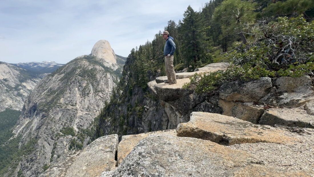
The trail swung southward, and Half Dome came into view for the first time. This also meant I was nearing my next destination, Glacier Point. After reaching it and chatting with some visitors about hiking up Half Dome, I headed to the store. I grabbed an ice cream sandwich and a soda. They also had pre-made sandwiches which sounded better than the tuna kit I had brought. Plus, it was mostly all downhill from here, so carrying a second lunch wasn’t going to be a burden. I enjoyed that ice cream out on the amphitheater, soaking in the stunning views. While I would have loved to just sit there for a long time, I still had a lot of miles to cover.

Now on the Panorama Trail, the vistas shifted to the Yosemite backcountry. Snow still clung to the mountain tops off in the distance. The trail crossed several small streams, some even flowing for a time on the trail itself. In a few weeks, I suspect they will be dry. Before too long, Illouette Falls came into view, which was my next stopping point. I took a short side trail to a viewpoint to marvel at them. This is actually the best place to view it, given how the water actually flows.

Once at the bridge over Illouette Creek, I took a short break. I initially thought I might have lunch there, but I was still full from that ice cream sandwich, so I decided to wait until Nevada Falls to enjoy it. Sadly, I saw the amount of trash scattered about the sandy beach, so I had to clean up what I could before continuing.

Now the trail would climb away from the falls. After about a mile and almost 600 feet of gain, I took another short trail to Panorama Point. I stood on an outcropping and took in the views. The trail leveled out for a while before descending toward Nevada Falls. I passed the closed junction to the John Muir Trail and found a nice shady spot near the river to enjoy my lunch. I took my time, soaking it all in. It was busy with groups of all kinds milling about.

That sandwich hit the spot, along with the Fritos, but it was time to descend down the Mist Trail. This was one part of the hike I was not looking forward to. This portion of the trail is steep and will also be crowded. Alas, there was no alternative, so down I went. This was also why I remembered to bring my rubber tips for my trekking poles to navigate the granite.

After crossing the river again at the Silver Apron, I left the Mist Trail to take the connector trail to Clark Point. This would allow me to bypass the crowds at Vernal Falls, and the wetter section of the Mist Trail. Upon reaching Clark Point, I was now back on the JMT. The final miles went quickly, and I was soon at Happy Isles Trailhead. I waited a bit for the shuttle to Curry Village, where a cold beer and some food awaited me, then decided to just make the flat one-mile walk. What’s one more mile after doing about 16?

At Bar 1899, the cold beer and pretzel bites were just what this hiker needed. I was also going to get a pizza, but there was a 45-minute wait, so I opted for a burrito instead. Since it was over two miles back to the car, I waited for the shuttle this time.

Finally back at the car, I changed into a dry shirt and made my way up to Tunnel View to enjoy the shadows slowly working their way across the valley. Again, this parking lot was almost at capacity. I can only imagine what Memorial Day Weekend would look like in a few days. As I looped back through the valley, I stopped at El Capitan Meadow. I decided to stroll out a bit, hoping to spot a climber’s headlamp on El Capitan. There, I ran into a gentleman with a nice spotter’s scope trained on a few climbers. He allowed me to look through it before he packed it away. He told me that those climbers were a 7-year-old attempting to become the youngest to climb El Cap and his brother, who was aiming to be the youngest to climb it twice (along with their support crew and father). To learn more about their successful climb, visit https://samadventure.com/.

It had been a long day, and while some astrophotography was tempting, I had a long drive home the next day. I awoke early and made breakfast while I finished packing up my site before making the drive home. The final stats for this hike were 15.5 miles, in 7:58 with over 4,507 feet of gain.


Buy Me a Coffee at ko-fi.com

I am an avid peak bagger, sometimes backpacker, and former sea kayaker living in San Diego. I am the co-author of Urban Trails: San Diego, available now!

In 2019, I became the third person to complete the San Diego 100 Peak Challenge. Not stopping with that accomplishment, I set my sights on the harder San Diego Sierra Club 100 Peak list, which I completed in 2021. In addition, I have conquered several Six-Pack of Peaks challenges (SoCal, San Diego, Central Coast, and both the Arizona-Winter and Arizona-Summer).

I am looking forward to exploring new summits and new adventures across the southwest. 

PCT – Apache Springs to Idyllwild

The winds did blow through the night, but unlike San Gorgonio, the tent held firm. I awoke just before dawn and enjoyed the colors over Palm Springs as I ate my oatmeal and had a cup of coffee. I gathered more water, being more careful not to kick up the silt. My filter was partially clogged, so it took some time to ensure I had enough water to reach Tahquiz Creek, the next water source.

Once packed up, I began the climb back to the junction. Sara had messaged me that she had just hit the trail herself. I said hello to some thru-hikers finishing packing up from their night up top. Apache Peak was right next to the trail, so I dropped my pack and followed the cairns to the summit. I found a sign and the register, but nothing to sign in. The views were something, but I had a lot of miles to cover, and this section was almost all in the sun.

Since my filter was working so slowly, I hung the CNOC bag from my pack, and my mini M!GO bottle was attached. Unfortunately, a brushy section knocked the bottle free. I found it with most of the water still inside, thankfully. It was worth a shot. I had my sun umbrella with me, but hadn’t attached the straps to fix it to my pack, and I was not about to just hold it through this section of the trail.

As I neared Spitler Peak, I opted to skip it as I just did not have the legs for the steep climb to the summit. If you have ever watched some videos of hikers doing this section in the winter, you realize how dangerous this portion of the trail is. However, the views to my east were breathtaking.

I came to a small saddle, spied two packs just off the trail, and then I saw a man coming down from the nearby slope. I shouted “hi,” and he returned the greeting by crossing his arms and giving me an almost death-like stare. My “spidey-sense” went off the charts—there was something very wrong with this dude. I gave him a thumbs up and kicked it up a notch to hike away from him. I glanced back to see if he might be following me, but thankfully, he did not seem to be. Soon, I caught up with Sara. Turns out she, too, had an odd encounter with him, as did some other hikers. We hiked together for a bit, filling each other in about our evening and the day so far. Sara still hadn’t found her climbing legs yet, so she suggested I just find my groove and meet at the creek. Since I had skipped Spitler, I knew I was going to be skipping Red Tahquitz. I crested the saddle and knew the rest of the hike was all downhill with some shade.

I leapfrogged another hiker, who asked me about how my side quests were going. Hum, I might have just gotten a trail name…”Side Quest”. About 8 hikers were relaxing by the creek when I arrived. I filled my CNOC and slowly filtered my water while eating my lunch. About 30 minutes later, Sara rolled in. We all collectively chatted about the odd hiker, and I said that since I was headed down to Idyllwild, I would let the rangers know.

After a nice break under the shade of the pines, Sara and I headed off along the blue blaze toward Saddle Junction. Once there, a volunteer ranger was checking permits. Poor Sara didn’t have a tag yet, so she had to dig her paper one out of the middle of her pack. I had an updated email for mine, so I was good to go. Two other hikers were relaxing before they made their way down to town. Since Sara had just been in town, she was going to keep pushing north. We said goodbye for now, and I, along with the other two hikers, headed down the Devil’s Slide trail. Hopefully, my good friends Rick and Andrea had shuttled my car up to Humber Park. Partway down, a text came through that they had indeed parked the car for me. Not sure who was happier—me, not having to wait for my car, or the two ladies, who now had a ride into town.

We met a few folks heading up the trail on a day hike and one thru-hiker heading back. Soon, the parking lot came into view, and this epic adventure had come to a close. I dropped the ladies off at the post office and let Rick and Andrea know I had picked up my car. They agreed to meet for an early dinner at the Idyllwild Brewpub, and I filed them in on my trip. They were tackling San Jacinto from Devil’s Slide the next day, so an early dinner worked well for them, as they had a long day ahead.

The final stats for the two days were:

Day 119.0 miles4,667 feet13:03
Day 213.2 miles2,343 feet8:57

Buy Me a Coffee at ko-fi.com

I am an avid peak bagger, sometimes backpacker, and former sea kayaker living in San Diego. I am the co-author of Urban Trails: San Diego, available now!

In 2019, I became the third person to complete the San Diego 100 Peak Challenge. Not stopping with that accomplishment, I set my sights on the harder San Diego Sierra Club 100 Peak list, which I completed in 2021. In addition, I have conquered several Six-Pack of Peaks challenges (SoCal, San Diego, Central Coast, and both the Arizona-Winter and Arizona-Summer).

I am looking forward to exploring new summits and new adventures across the southwest. 

PCT – Highway 74 to Apache Springs

I awoke just before the alarm went off and quickly got ready.  I was driving up to Idyllwild and picking up Sara to shuttle her back down to the Highway 74 trailhead before joining her once again on the Pacific Crest Trail. However, this time I would not just be day hiking; I would be backpacking this section of the trail all the way back to Idyllwild. I grabbed breakfast and coffee for Sara and me at the 24-hour McDonald’s in Temecula, then continued up the mountain to pick her up at the rental cabin she was sharing with some other thru-hikers. I got there right around 6 am, and Sara was soon in the passenger seat, ready to hit the trail once again. We pulled into the trailhead parking lot and quickly gathered our gear. We had a long, hard day of hiking ahead of us, and we wanted to get moving. Off to our north, we could see San Jacinto beckoning. We passed a stone monument with a map of the PCT and a memorial for Andy Elam, who, unfortunately, was murdered nearby back in 1989.

The trail started off mellow for a bit before the long climb began. We passed someone who had found a nice spot for the night. Sara continued filling me in on the events since I last saw her up on Mt. Laguna. Before too long, we came to the junction that one would take to summit Ken Point. While I was hoping to climb several side peaks on this trip, this summit was a bit too far for my liking. We enjoyed the views, mostly to the west. I tried to spot the peaks that I had climbed the week before. After a couple more miles, I came to the use trail that would take me to the summit of Lion Peak. This climb would be an out-and-back, so I dropped my pack off to the side of the trail and followed the cairns to the summit. I found the register and a nice wooden sign. I snapped a few photos, signed the register, and hustled back down. We still had a lot of miles to cover. Sara was waiting for me under the shade of a nearby tree.

About 1/2 mile later, we reached the junction with the use trail to Pine Mountain. I debated on this one, as the trip reports indicated it was a bit brushy and a bit further off-trail. In the end, I opted to skip it. The day was getting warmer, and I was trying to be mindful of my water and energy. Just to the north, Pyramid Peak was calling my name. Unlike the climb to Lion Peak, this time I kept my pack on, as the route made more sense to climb it as a point-to-point. The use trail to the summit was pretty well marked. Once at its rocky summit, I had some fantastic views. Found the benchmark, two reference marks, and the register. I took a short break and enjoyed a snack before heading down the north ridge, again following a good use trail.

Sara had passed me while I was on the summit, but we planned to rendezvous at the junction for Cedar Springs. I found her enjoying her lunch in the shade with some other thru-hikers. One had just returned from the mile hike down to the spring to refill their water, and others were getting ready to make the same trek. Our original plan was to hike down and camp there for our first day, but it was just a bit after 1 pm, and we both agreed it was too early to call it a day. We could certainly top off our water, but the thought of those 2 miles was not appealing. Instead, we opted to make the short hike to Eagle Spring and fill up there. Using the references in the comments on FarOut, we found the lone pine tree and the use trail that led to a trickling spring and a water trough. Sara used the spring, while I carefully filled my CNOC from the trough, trying to keep the algae away. Once we had filled our bottles, we climbed back up to the PCT and continued on.

Since we had changed our initial plans, I was also reviewing my peak bagging side quests. The next peak on my agenda was Palm View Peak. On paper, this looked to be the easiest of all the ones I hoped to climb. Very little elevation gain and barely off-trail. I dropped my pack and set off. Sara kept pushing northward, knowing that I would catch her on the big climb that lay ahead of us past Fobes Saddle. The hike over to Palm View Peak started nicely, with some nice shade from the trees, until I hit a wall of brush. I tried to match my position to the tracks I had saved, but nothing really indicated a route through them. Relying on bushwhacking talents, I picked my way through until I spied a small mound of rocks indicating the summit. The register was soaks, and the views were less than stellar. I snapped a few photos and pushed my way back out. 

The trail descended to Fobes Saddle, and the sun was slowly sinking behind Thomas Mountain. Spitler Peak loomed to my north. This was on my list, but there was no time to climb its steep slope and still make camp at Apache Springs. If I were solo and had climbed Ken Point and Pine Mountain, I probably would have made Cedar Springs later in the afternoon, so stopping there would have made sense. I knew there was a closer trailhead for this peak, so returning would not require re-hiking much of the PCT. I was now a good distance ahead of Sara, so we were coordinating digitally. I had some water left, so I did consider stopping short of Apache Springs for the night, then dropping down to it in the morning to fill up for the day. FarOut indicated a campsite before the junction with Apache Springs, but when I reached it, it seemed pretty full and exposed. So, I pushed on toward Apache Springs. At the junction, some folks had set up camp. I had been leapfrogging with some, so I asked them to let Sara know that I was headed down to the spring. 

Apache Spring sits about 0.6 miles off the PCT and has a 520-foot elevation loss. As I started down, I hoped there was a spot for my tent, since I was not keen on hiking back up to the junction. Partway down, I passed one tent just off to the side of the trail. I thought to myself, great, if someone is camping here, are there even any spots near the spring? But as luck would have it, there was no one camped there! I found a nicely sheltered spot, since I knew it was going to be breezy overnight (25-mph gusts were predicted). After I got my tent set up and secured, I walked the few minutes to the spring itself. It was getting dark, but I thought I had enough light, so I left my headlamp behind. I gathered some water and hauled it back to the campsite. Once there, I saw how slity it was. When I scooped up the water, I disturbed the silt. I let it settle some before dumping out a portion and starting to filter it. I was pretty beat and decided not to spend the time or water on cooking dinner. Instead, I ate my Walking Tamale, a beef stick, and my mini-apple pie for dinner, then turned in for the night under the glow of the lights from Palm Springs. I had gotten a message from Sara that she had reached the junction and was camping up there. With that, I turned off my headlamp and drifted off to a well-earned sleep. I covered 19.2 miles in 13:03 total time and an elevation gain of 5234 feet.


Buy Me a Coffee at ko-fi.com

I am an avid peak bagger, sometimes backpacker, and former sea kayaker living in San Diego. I am the co-author of Urban Trails: San Diego, available now!

In 2019, I became the third person to complete the San Diego 100 Peak Challenge. Not stopping with that accomplishment, I set my sights on the harder San Diego Sierra Club 100 Peak list, which I completed in 2021. In addition, I have conquered several Six-Pack of Peaks challenges (SoCal, San Diego, Central Coast, and both the Arizona-Winter and Arizona-Summer).

I am looking forward to exploring new summits and new adventures across the southwest. 

Up the Mile High Trail

Initially, the weather seemed favorable enough for me to attempt Rosa Point and Mile High in Anza-Borrego. Slowly, however, the forecast became slightly warmer than ideal. It was my birthday weekend, though, and what better way to celebrate than with some solo camping in the desert and hiking? After our book signing event at Warwick’s, I gathered my things and headed off toward the desert. I knew I wasn’t going to arrive until closer to sunset, so I opted to get a burrito from Los Jilbertos in Borrego Springs for dinner. I pulled off the S22 for the Arroyo Salado Campground. Since it was Sunday, the campground was empty, and I had my choice of sites. I quickly began setting up and had the chance to use my levelers for the first time, as there was just enough grade to offset.

I enjoyed my burrito and chips while a fire danced in the fire pit. There was a slight breeze, so the fire burned quickly, which was fine as I was planning on an early morning. It was still quite warm, and I wondered how much it might actually cool off overnight. I enjoyed some night skies for a bit before turning in. The alarm went off at 4:30, and I quickly made some oatmeal and coffee. After breaking camp, I made the short drive back to the trailhead. This is the same trailhead from which to start for Villager or Pyramid Peaks. There was no moon to help illuminate the desert floor, but my headlamp guided me toward the Palo Verde Wash off to the northeast. Unlike my previous time climbing these peaks, I planned to ascend the ridge much sooner to avoid hiking through the rather rocky wash and the steep ascent that would otherwise be required. I found a cairn and a clear use trail right where my track indicated it would be. The temperature had only dropped to about 70° F, so I wasn’t sure I’d be able to summit today. I  figured if I could, at the very least, explore this route a bit. The use trail was really well defined, and I had no trouble working my way up the ridge. The sunlight began to fill the desert around me, illuminating the badlands around Fonts Point and the mountains to the west, but I was still in the shade from the mountains to my east.

Various cacti dotted the landscape as the trail steadily climbed. Like any route in the Santa Rosa Mountains, you had to deal with varying terrain; sometimes great footing, other times less than ideal. The trail did pass through a few cholla fields, so I tried to take extra care to avoid getting “cholla bombed”. Sadly, one did get me, but I got all the spines out that had made it through my pants and sock and into my ankle. As I drew near the junction where I needed to decide whether to continue toward Mile High or veer off to the northeast and ascend Rosa Point. I found a spot to take a break, enjoy a snack, and drink some electrolytes. I carry a Bluetooth temperature gauge, so I pulled up the app to see what it was reading.  Currently, it was 76°F, so maybe I would just summit Mile High and call it a day.

I set off along the trail for about another ½ mile and decided to call it. I had at least 2 more miles with over 2,000 feet still to climb to reach the summit. While I was carrying almost 4 liters of water, I wasn’t comfortable continuing. As the famous mountaineer, Ed Viesturs, says, “Getting to the top is optional. Getting down is mandatory.”

I popped in my headphones and began listening to various podcasts as I made my way back down. The day continued to heat up, and once I reached the desert floor, I pulled out my sun umbrella and cruised back toward the car.  Once there, I tossed in my gear and let my wife know I was safe and sound. The temperature was in the mid-80s, so I knew I made the right call. However, finding that use trail that allows skipping so much of the hiking in the wash was a win, and that will certainly be helpful when I return. All told, I spent 5:40 out on the trail, covering 8.1 miles with just over 2,753 feet of gain.


Buy Me a Coffee at ko-fi.com

I am an avid peak bagger, sometimes backpacker, and former sea kayaker living in San Diego. I am the co-author of Urban Trails: San Diego, available now!

In 2019, I became the third person to complete the San Diego 100 Peak Challenge. Not stopping with that accomplishment, I set my sights on the harder San Diego Sierra Club 100 Peak list, which I completed in 2021. In addition, I have conquered several Six-Pack of Peaks challenges (SoCal, San Diego, Central Coast, and both the Arizona-Winter and Arizona-Summer).

I am looking forward to exploring new summits and new adventures across the southwest. 

No Knob!

Originally, I had planned to hike up to Rosa Point and Mile High on Sunday, but one set of friends had to back out, and another let me know that his legs were a bit worn from climbing Sawtooth (the one on the SD Peak Club list). So I suggested that Robert and I explore and see if we might be able to climb Knob Benchmark from Sheep Canyon. At worst, it would be another great hike out to Sheep Canyon, and we’d probably have some wildflowers to enjoy as well. We met around 7 at the parking lot next to Jilbertos and transferred into the Outback. Robert and I drove out to the gate at the third crossing. We parked, gathered our gear, and set off. There were quite a few more flowers than last time as we hiked along the stream.

After the climb over Boulder Alley, we met a group of Boy Scouts returning from their overnight. Earlier, we had met a couple of bike-packers. As we got closer to Sheep Canyon, we could see where the recent rains had traveled across the desert sands. We walked over to the campground where another group of backpackers was milling around a picnic table. I assumed they might be WBC course participants, since a lecture was being held. Even with the closure, this is still a busy place. We found another table and had a quick snack break. Now onto the real adventure—could we find a route through Sheep Canyon, then onto Knob Benchmark? The route I had taken before is no longer available, so I was exploring alternatives.

As we headed into the canyon, the sounds of flowing water began to fill the air. A really good flow poured through the brush. That is a good sign for us if we can get in a backpacking trip to attempt SquareTop, as we will need to haul out very little with us. Maybe we could bring some firewood instead? We began slowly, picking our way through the brush and rocks, crossing the creek a few times. After almost an hour of pushing through the increasingly dense growth and only covering about 1/2 mile, we called it. We felt the canyon was going to get thicker and harder. Knob Benchmark is going to require a different route. We got back to the campground and had another snack before heading out. The day had warmed some, an indication of the warmer forecast for the coming week. We cruised back, stopping at the marker again. As we neared the gate, there were a lot more folks out enjoying the flowers. We drove back into town, grabbed a couple of sodas, and enjoyed our lunch at a picnic table under the shade of a cottonwood. While we never got close to the peak, it was still a fantastic day in the desert with some good company.


Buy Me a Coffee at ko-fi.com

I am an avid peak bagger, sometimes backpacker, and former sea kayaker living in San Diego. I am the co-author of Urban Trails: San Diego, available now!

In 2019, I became the third person to complete the San Diego 100 Peak Challenge. Not stopping with that accomplishment, I set my sights on the harder San Diego Sierra Club 100 Peak list, which I completed in 2021. In addition, I have conquered several Six-Pack of Peaks challenges (SoCal, San Diego, Central Coast, and both the Arizona-Winter and Arizona-Summer).

I am looking forward to exploring new summits and new adventures across the southwest. 

Returning to Coyote Mountain

Decided to tackle one of Ted’s remaining peaks on his 100-peak list today. Given his time constraints, Coyote Mountain seemed to fit the bill perfectly. Our drive out had us under overcast skies, but as we dropped down to the desert floor, we left the clouds behind. Unfortunately, not the wind, as it was breezy as we got out of the car. We had the same issue the last time we tried to climb this mountain. The winds were not as strong, and we decided to at least get on the ridge and see how we felt. We crossed the rocky desert floor to the ridge that lay off to the west. As we drew near, we spied some cairns.

Once on the ridge, we could feel the wind, and it was strong enough to move our trekking poles, but nothing beyond that. We decided to continue; however, this was to be a silent climb, as we certainly were not going to be chatting over the wind. The route was almost overmarked with cairns, as well as the fairly well-defined use trail that followed the ridge. For the most part, we kept our heads down to avoid our hats being blown off, and pushed upward. The route goes mostly north, before turning westward to the summit, with a couple of short flat sections. The last time I climbed this peak, I needed to rest from time to time. For this climb, we kept hiking, except to snap a photo here and there.

We reached the wide, broad summit, found the register and benchmark. I signed us in and opted not to enjoy the can of Coors that was in the ammo box. After a quick snack and various photos, we headed back down as the wind was still blowing and there was nothing on the summit to act as a windscreen.

After a few minutes descending, the winds ceased. Since we no longer had to keep our heads down, we could enjoy the expansive views to our east, and we could have a conversation. Along the way, we met two other hikers taking a short break on their ascent. We chatted for a bit before parting ways. Once at the base of the ridge, we followed more cairns that took us farther east than the route we took on the way in. We passed an old water tank, then finally back onto the road, and then our car. We tossed our gear in and changed into some dry shirts, then drove along the road to inspect a structure near the edge of the dry lake bed. This is a small shack labeled as “The Peace House”, and it was quite interesting. Since it is wildflower season out in the desert, here are the various flowers we spotted along our adventure:

After grabbing some Mexican food in town, we headed home. I logged 5.4 miles, while Ted had us at just under 6. Our total time was 3:43, about 45 minutes faster than my last time. The entire climb was 2,573 feet.


Buy Me a Coffee at ko-fi.com

I am an avid peak bagger, sometimes backpacker, and former sea kayaker living in San Diego. I am the co-author of Urban Trails: San Diego, available now!

In 2019, I became the third person to complete the San Diego 100 Peak Challenge. Not stopping with that accomplishment, I set my sights on the harder San Diego Sierra Club 100 Peak list, which I completed in 2021. In addition, I have conquered several Six-Pack of Peaks challenges (SoCal, San Diego, Central Coast, and both the Arizona-Winter and Arizona-Summer).

I am looking forward to exploring new summits and new adventures across the southwest. 

Returning to Goat Benchmark

The plan was to hike out to Goat Benchmark with Rick & Andrea, and if I was feeling up to it, I might push on to The Sirens and San Ysidro East. With the access closure from Lease Road, the only real option for us to hike to Goat Benchmark was to start from Montezuma Valley Road. I had hiked portions of this route, as far north as White Benchmark, but not between that point and the route I had taken before on my trips into Hellhole Flats. I arrived a bit early and saw the sunrise was really putting on a show, so I continued past our meeting point and drove farther along Montezuma Valley Road to a couple of turnouts to capture it. What a sight!

We were meeting at 7, so I turned around safely and met them at the fence line of Anza-Borrego State Park. The general plan was to head north, following the fence line (and the terrain), then link up with the gully descending toward Hellhole Flats. I was almost over a cold, so I wasn’t sure I had the energy to make the whole trek, but I carried enough to do so. At a minimum, I would have eyes on that new section that I would have to traverse at least once more with Ted to hike up to San Ysidro Peak. The recent rains made the ground a bit soft and damp. The brush was low, so our pants should remain dry. This new route adds about 1.5 miles to the junction of the routes and about 1,000 feet. We worked our way northward, following small use trails and trying to avoid unnecessary climbs. As we approached White, the route options became more complex, with more boulders and steep sections to contend with. We tried to follow the contour lines, but eventually opted to head up toward White Benchmark and a gap to its north. In hindsight, I think it would have been easier just to follow the slope south toward White, then cut across near the summit to that gap. That is what I did upon my return, and that is the better route.

After passing White, we tried to stay on the east side to avoid the property line. A small bump sits just to the north of White, and we found ourselves unable to continue. We debated heading straight east and down a steep slope, then up toward Goat from there, but we opted to try the west side and hug the property line. After a couple of downs and ups across some minor gullies, we turned onto one that would eventually link with the gully that I have used in the past. Once in it, we cruised along. At one point, we had a bit of flowing water that appeared briefly, then faded back underground. I kept a mindful eye for the turn off to Goat. I spotted a familiar landmark, just a small bump, and knew we were getting close. One thing I remember about Goat is that it is not the pile of rocks you think it is, nor the next one… Once there, we took a short break, and I pulled out my wind shell, as it was chilly and breezy. We had been adding and removing layers throughout the hike. We signed the register and snapped a photo of the benchmark. Rick and Andrea were hoping to continue and make it to Webo. I kept debating about my options. I had broken down the various sections for my attempts, and it seemed too much, as we had lost some time on the way out. Plus, the weather was supposed to worsen in the afternoon. I made the call that I was going to retrace our route. I then suggested, since they would be at Webo, why not just take the ridge down rather than slog back the way we came? I could drive down to the parking area and shuttle them back. So, that became the new plan. I gave them a few navigational pointers, and we parted ways.

I found some nice use trails to return me to the main gully, then to the side gully to begin my journey south. I was able to follow our route in with no issues. As I approached White, my right knee began to ache. Not sure if it was cold, or overused, but I was not happy. I wondered if the soft terrain had put some stress on it… Since I was so close to White, I opted to climb it formally. As I mentioned earlier, our route out almost took us to its summit. I climbed the rocks to the top, and then took a quick break for a PB&J. Both Rick and I had cell coverage, and they were atop Webo hunting for the benchmark and the register. They found the benchmark, but the register could not be located. The same was true for me. I could see a pile of rocks on top where one might have been, but no more. I did not look that hard to see if it had been relocated. I then headed southward, not following any particular track, letting the terrain guide me. Since my knee was hurting, I skipped climbing some of the other benchmarks scattered along the way. It had gotten colder and windier, so I was wearing all my layers. Ignoring my knee, I suspected I made the right call to not stay out longer.

Back at the car, I changed and drove on down to Borrego Springs. I grabbed a cold soda from the market and played on my phone a bit while I waited. I got a check-in message from Rick, and eventually made my way over to the parking lot for Hellhole Canyon. I relaxed for a bit until I spotted two tired but happy hikers emerging from along the trail. They tossed their gear in the back, and we made the drive back up to Ranchita. As we drew near where we started from, rain was falling! Boy, did we all make the right choice. It would have sucked hiking back in that! I tracked my hike at 8.3 miles over 6:15 with 2,087 feet of gain.


Buy Me a Coffee at ko-fi.com

I am an avid peak bagger, sometimes backpacker, and former sea kayaker living in San Diego. I am the co-author of Urban Trails: San Diego, available now!

In 2019, I became the third person to complete the San Diego 100 Peak Challenge. Not stopping with that accomplishment, I set my sights on the harder San Diego Sierra Club 100 Peak list, which I completed in 2021. In addition, I have conquered several Six-Pack of Peaks challenges (SoCal, San Diego, Central Coast, and both the Arizona-Winter and Arizona-Summer).

I am looking forward to exploring new summits and new adventures across the southwest. 

Out to Bernard and Little Berdoo

I awoke just before sunrise. After a nice warm breakfast, I drove down Geology Tour Road to the start of the hike. The road was in pretty good condition, except for two rutted spots that were muddy and had been “enjoyed” by others. At marker 14, I turned off the road and parked. I left a note in the window, grabbed my gear, and set off.

I worked my way eastward toward the wash, which I would follow southward for about 1.5 miles, when it split into two forks. Here, a large cairn marked the exit from the wash, and the climb would begin in earnest. My route took me up a gully and toward a small saddle. A lone boulder just to the east of it helped give me a target to aim for. Once along the ridge, it was now a “simple” process to follow it in a generally southward direction, ever climbing. The route would alternate from mild to steep. After a very convincing false summit, the true summit of Bernard Peak came into view. I scrambled to the summit. A light breeze helped temper the day’s warmth. I found the benchmark and a reference mark. I signed the register before setting off for the next peak (Little Berdoo) after addressing a hot spot on my foot.

I dropped down to another saddle, sad to lose some elevation, but I did pick up an excellent use trail for a while. My route arched over to the summit. Here I found the benchmark, reference mark, and the register. The Coachella Valley was spread out before me as I enjoyed a snack and some electrolytes before heading back.

My route back went well with a few drifts off track, but I quickly corrected my navigation. I enjoyed a Walking Tamale, a new trail food for me, during one of the mellower sections to keep my energy levels up. Way off to the north, I could see the volcanic rocks of Malapai Hill and Geology Tour Road, as I kept descending. Soon, I passed that lone boulder again and down to the wash. Initially, I planned to follow the wash back to the road, then to my car, to avoid the open desert portion again. With a quick check against the saved GPX track I had been using, I saw that I was drifting to the east, so I was going to have some last open desert hiking before reaching the road.

Once back at the car, I enjoyed some cold water, as the day was now in the mid-70s. The thought of hiking up volcanic rocks to the summit of Malapai Hill on a warm day with some tired legs was not something that appealed to me. Tonight’s campsite was down at Cottonwood Springs, so I had a bit of a drive to recover from the day’s efforts. I stopped at the visitor center to ask about the road to the Monument Peak trailhead. The rangers said that up to that point, an AWD car would have no issues. Past that, well, you’d better have a real 4×4 with recovery gear. I got the same campsite as I had last year. The light pollution is a bit worse here, so astrophotography wouldn’t be as good. I quickly set up camp and started cooking while I started a campfire. Unlike last night, there was no breeze, so it was an enjoyable night to enjoy a nice beer and watch the fire.

I awoke slightly before dawn and captured a short time-lapse of the sunrise.

After some oatmeal, OJ, and hot coffee, I decided not to attempt Monument Peak. My legs were still spent from the past two days, and as I still needed to climb Malapai Hill, I knew I had a return trip to Joshua Tree in my future. With that decision, I headed home very satisfied with the hikes and camping. The entire multiple peak hike covered 8.7 miles in 5:44. The total elevation gain was 2,221 feet.


Buy Me a Coffee at ko-fi.com

I am an avid peak bagger, sometimes backpacker, and former sea kayaker living in San Diego. I am the co-author of Urban Trails: San Diego, available now!

In 2019, I became the third person to complete the San Diego 100 Peak Challenge. Not stopping with that accomplishment, I set my sights on the harder San Diego Sierra Club 100 Peak list, which I completed in 2021. In addition, I have conquered several Six-Pack of Peaks challenges (SoCal, San Diego, Central Coast, and both the Arizona-Winter and Arizona-Summer).

I am looking forward to exploring new summits and new adventures across the southwest. 

A Veterans’ Day hike up El Cajon Mountain

Saturday was the County of San Diego Parks and Recreation’s 10th anniversary warrior challenge hike up El Cajon Mountain. Ted and I had done the same challenge on Memorial Day, and by repeating this hike for Veterans Day, we earned some additional patches and challenge coins! We found one of the last spots along the northbound Wildcat Canyon road and gathered our gear. At the trailhead, we signed in with the rangers, each grabbed our carabiner, a snack, and a photo together, then set off. The carabiners would be used to collect knots from each station along the route. Since we both had hiked this peak multiple times, we just threw it into cruise mode and motored along. We would pass fellow hikers from time to time, and even a couple already returning from the summit (we assumed they had timed their hike to enjoy the sunrise). The aid station at the one-mile mark wasn’t staffed yet, so we would have to grab our knot on the way back. We kept a solid pace as we pushed on toward the next station at the three-mile mark. That station was also not staffed yet, so we would also need to stop here on our descent.

The day was warming up, and that early start was a wise choice. Soon we passed that rusting truck, and thereafter the saddle between El Cajon and El Capitan. We had a quick break before the final steep push to the summit. The familiar green trail markers led us up the slope. A few hikers were milling around the summit, and I recognized James Alvernaz. I had met him a few weeks back at the parking lot at the Idyllwild Ranger station; he was headed up toward Tahquitz and I was off to the summit of San Jacinto. We recognized each other and chatted for a bit. After some snacks and grabbing a few photos, it was time to head down. Plus, there isn’t a lot of room at the summit, and it can get crowded up there.

The initial descent was a bit slow, as many other hikers were making their way up. But once we reached the saddle, the trail widened and we could usually pass without needing to stop. At the three-mile station, now staffed, we grabbed our knots, some snacks, topped off our water bottles with some cold water, and continued our descent. As we neared the one-mile station, we noticed a hiker in some distress, and stopped to see if we could help. Another hiker had been cruising down with us, and between the three of us, we got him some electrolytes and some quick energy gels. He had a companion with him, so we let him rest and let the electrolytes start to take effect. Just a few minutes later, a ranger drove up in a small cart, and we let him know there was a hiker in distress by the nearby kiosk. We later learned that they gave him a lift back to the trailhead.

At the one-mile station, we got our final two knots and a few more snacks. Now the conversation turned to essential matters—lunch. We mulled over the options as we continued down. Once at the trailhead, we collected our patches and coins and thanked the rangers and volunteers for their hard work. Once back at the car, we had settled on Board & Brew as our lunch spot. We hiked the 10.8 miles in 5:27. And remembering how we commented on the heat, the thermometer in the car read 88°F!


Buy Me a Coffee at ko-fi.com

I am an avid peak bagger, sometimes backpacker, and former sea kayaker living in San Diego. I am the co-author of Urban Trails: San Diego, available now!

In 2019, I became the third person to complete the San Diego 100 Peak Challenge. Not stopping with that accomplishment, I set my sights on the harder San Diego Sierra Club 100 Peak list, which I completed in 2021. In addition, I have conquered several Six-Pack of Peaks challenges (SoCal, San Diego, Central Coast, and both the Arizona-Winter and Arizona-Summer).

I am looking forward to exploring new summits and new adventures across the southwest. 

Ascending San Jacinto

With the Palm Springs Aerial Tram closed for its annual maintenance, I had three options to ascend Mt. San Jacinto: via Marion Mountain Trail, Devil’s Slide Trail, or Deer Springs Trail. I had done the first two routes, so I decided to try taking the Deer Springs route to the summit. Initially, I had planned to do this as a backpacking trip staying at Little Round Valley, but the weather forecast called for a 40% chance of snow showers, so that was not going to happen. Instead, I opted to just do it as a long day hike instead. I pulled into the Ranger Station in Idyllwild and found that the only permits were for overnight trips. Given the government shutdown, it did not surprise me that the day-use permits had run out. So, figured I would hike without having one (they are free). From there, I made the short drive to the parking area for Deer Springs Trailhead. I shouldered my heavy pack and set off. I opted to carry 2.75 liters of water, as well as my Sawyer filter. According to SacJacJon.com, there should have been some water flowing at various spots along the trail, and the rains from the day before should ensure the flows were good. The temperatures were in the mid-50s, and the skies were partly cloudy as I set off up the trail. I knew I had a long, hard day ahead of me and tried just to keep a steady pace. I mentally broke the hike down into sections, from each trail junction to the next. My first milestone was the turn off to Suicide Rock about 2.1 miles in. Here, I made sure to have a quick snack while I continued my climb. The next up was Strawberry Junction, 1.6 miles later. There, I would now join the Pacific Crest Trail for a while.

When the PCT met with the Marion Mountain Trail, I decided to take a break and have another snack. A Sierra Club Los Angeles outing also arrived just as I did, and also took a short break. It was still cool, and I had worked up a sweat, so I slipped on my fleece to keep from getting a chill. I chatted with some of my fellow hikers. Their plan was to climb Marion Mountain and Drury Peak, two of the several Hundred Peak Section peaks scattered around San Jacinto. I stashed my fleece and set off up the trail toward the junction with Fuller Ridge. However, the breeze was a bit stronger on this side of the mountain, and I quickly stopped and put my fleece back on. Deer Springs was flowing quite nicely, so if I returned this way, I knew I had a solid water source to rely on. The Sierra Club hikers stopped at the Fuller Ridge junction, and I continued, leaving the PCT behind. After about 1.2 miles, I came to Little Round Valley. Some hikers were milling around the creek that was flowing just before the campground. If I had been able to camp here, I would have had a good water source. I looked over some of the campsites. While you can’t reserve them, you are supposed to camp at one of the designated locations. There is a simple outhouse here. Now, it was time for the final push to the summit. I had about 1.2 miles and over 800 feet of gain to reach the junction with the Peak Trail. I could start to feel the effects of the trail as I worked up the steep slope. I was over 10,000 feet up, and I could definitely tell. 

I realized I should have had another snack in Little Round Valley, but opted to continue on. Initially, I had planned to stop at the junction for lunch, but the wind made things a tad chilly, so I decided to head for the Emergency Hut that sits just below the summit. I stepped inside, slipped off my pack, and stretched out on one of the bunks. I mixed up some electrolytes and ate my PB&J and oranges. I had a touch of cell service, so I checked in with my wife and let her know my status. Feeling much better, I shut the door to the hut and made the short scramble to the summit proper. The hikers I had passed in Little Round Valley were mingling around. I grabbed a few photos for myself and took a few for them. According to my Govee, it was 48°F and probably 10-15 mph winds, with some stronger gusts. I made the right call to enjoy my lunch in the hut. 

With that summit, I completed all 12 peak options on the Six Pack of Peaks Challenge! Now for the long descent back to the car. I debated whether I should retrace my route or head back via Wellman Divide, then over to Strawberry Junction. Since I had never hiked the section from Annie’s Junction to Strawberry, why not? I still had enough water on me, plus I would be passing the Wellman Cienaga if I needed to refill. The descent went smoothly, partly because I brought my rubber tips for my trekking poles, which made them extra grippy through the rockier sections. I stopped at Wellman Divide for another snack and to drink some more electrolytes before continuing down. I also stashed my fleece, as the winds had almost died down completely. At the cienaga, I filled my CNOC bladder with about a liter of water. I did not need it then, but I could not fully remember if I had any remaining water crossings below Strawberry Junction (Narrator: There was one). At Annie’s Junction, I left the Mount San Jacinto State Wilderness and crossed back into the San Jacinto Wilderness. As an added bonus, I rejoined the PCT. The Strawberry Cienaga was dry, and I hiked past it. After getting slightly off the trail a bit due to my wandering over to enjoy a vista, I stopped at the Strawberry Campsite. The campers had their tents set up, ready to enjoy their overnight stay. There was another site off to the west that I might have to come back and enjoy next season. 

Back at Strawberry Junction, I saw a trail runner I had seen at the summit. It turned out he missed the turn-off at Annie’s Junction and headed down toward Humbler Park via the Devil’s Slide. He opted to retrace his route rather than continue, but it had added another 6 miles to his already long day. I would have continued down and hitched a ride. I offered some water or food if he needed any. He declined both. We opted to hike the remaining 3.6 miles together, chatting about a myriad of things. Once back at his car, he thanked me for the conversation, saying it had helped distract him during the descent. I then checked my tracker and saw it had stopped a bit after Strawberry Junction. I took a screengrab to record what had been logged, along with an approximate timestamp. With a bit of work, I filled in the missing data. It was now just a touch after 6 pm, almost a full 12 hours on the trail. I let Anita know my status and when to expect me home. All told, I hiked 19.2 miles, with a moving time of 10:10 and an elevation gain of 5,240 feet!


Buy Me a Coffee at ko-fi.com

I am an avid peak bagger, sometimes backpacker, and former sea kayaker living in San Diego. I am the co-author of Urban Trails: San Diego, available now!

In 2019, I became the third person to complete the San Diego 100 Peak Challenge. Not stopping with that accomplishment, I set my sights on the harder San Diego Sierra Club 100 Peak list, which I completed in 2021. In addition, I have conquered several Six-Pack of Peaks challenges (SoCal, San Diego, Central Coast, and both the Arizona-Winter and Arizona-Summer).

I am looking forward to exploring new summits and new adventures across the southwest.